Contents
Index
Threatened Marks
GeoCadastre has been modified to allow for reporting threatened marks.
Details of the remarked points are output to a .csv file
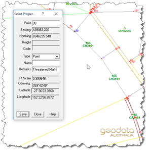
This is achieved through the Point Properties dialog box.
Before attempting to do this make sure you have added an enabling statement to your GeoCadastre Config file.
The following statement is required
<menuEntry menuText="Points with RMS Report" menuItem="MENU_POINTS_WITH_RMS_REPORT"/>
This statement goes into the first part of the config file and before the <MenuColumn> statement.
Add Remark to Point Properties
Open the relevant job in GeoCadastre and select the point at which you want to record the threatened mark,
add in the "Remarks" window the "Threatened Mark" statement to each point referencing a mark which may be threatened.
The Threatened Mark feature simply reports a cadastral mark at which a survey mark exists and may be threatened.
It does not record the details of the mark, just flags the fact that it or they may be threatened by construction;
the plan on which the mark exists is also recorded and output to the csv file.

Add Remark to Point Properties
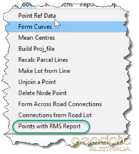
Go to Extra Tools and select "Points with RMS Report" which will have been exposed by the above
referenced edit to the config file.

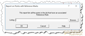
This exposes the dialog box allowing you to nominate the file name and path for the resultant report.
Note that this report will also include any other Remarks which may have been used on points elsewhere
in the job, not only the Threatened Marks

Reference Marks
See this topic for more information


